

The evolution of intermodality in Madrid
- Like
- Digg
- Del
- Tumblr
- VKontakte
- Buffer
- Love This
- Odnoklassniki
- Meneame
- Blogger
- Amazon
- Yahoo Mail
- Gmail
- AOL
- Newsvine
- HackerNews
- Evernote
- MySpace
- Mail.ru
- Viadeo
- Line
- Comments
- Yummly
- SMS
- Viber
- Telegram
- Subscribe
- Skype
- Facebook Messenger
- Kakao
- LiveJournal
- Yammer
- Edgar
- Fintel
- Mix
- Instapaper
- Copy Link
Posted: 11 June 2017 | Javier Aldecoa, Transport Interchanges Project Manager at the Transport Authority of Madrid (CRTM) | 1 comment
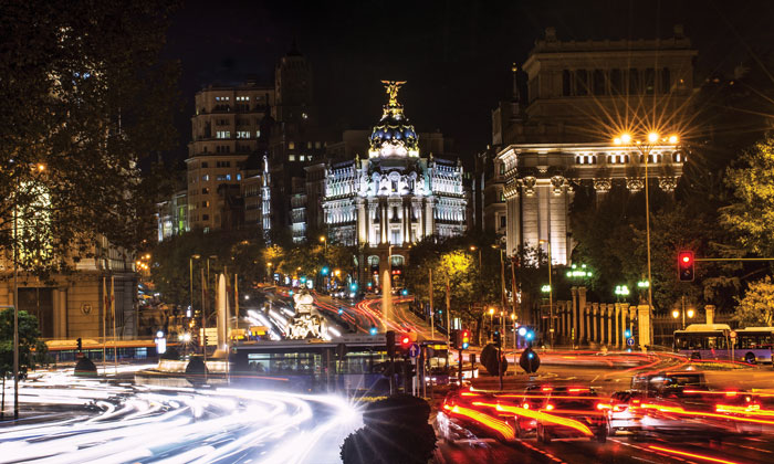
Javier Aldecoa, Transport Interchanges Project Manager at the Transport Authority of Madrid (CRTM) gives an overview of Madrid’s inter modal transport evolution, illustrating the journey from the city’s original main ‘gate’ hubs to its current network interchanges.
Being initially a privilege of the aristocratic and bourgeois classes, public transport experienced a boost in development once communication between Madrid and other distant urban centres became a necessity that demanded a more economical and accessible transport system. The increase of these services, along with the diversification of the means of transportation, quickly caused congestion problems at the points of transfer. Throughout the last century, these same problems have been offered with a variety of diverse strategies and solutions – some more successful than others.
All in all, the history of intermodality in Madrid tells the story of an evolution that has allowed the urban web to unite all of its branches, extending from the main gates which have since been transformed into important public transport interchanges.
Since the time of its creation in 1985, the CRTM (the Transport Authority of Madrid) has considered intermodality to be a main priority within the following different fields of action: infrastructure, ticketing and the cities overall image. The integration efforts between different transport modes are most effectively realised within the interchanges.
Essentially, interchanges play the same role in today’s cities as that of the gates in the walls of centuries-old medieval city. At this moment, interchanges are the gates to the cities of the 21st century.
Visionary architect and urban planner, Arturo Soria, who designed Ciudad Lineal at the end of the 19th century, once said that in a time of war, Madrid would be a very vulnerable city due to the ease with which it could be invaded. In such a situation, the city’s only option would be to protect its limited and narrow entryways by trapping citizens inside a dangerous mouse hole. It is true that until the end of the 19th century, when Madrid began to grow beyond its boundaries and initiate an era of urban expansion, the city remained contained behind a giant wall built in 1625. Surprisingly, despite its rapid expansion and urban transformation over the years, the city has maintained the same entryways, modifying only what was deemed necessary for the modernisation of highways and public transportation.
In this sense, it is the concepts of transport ation and intermodality that have experienced the most radical changes over the years.
In 1792 the first public transport service inside the city of Madrid started being used by the upper class, with stops in the centre of the city: plaza de la Cebada, Santo Domingo and Puerta del Sol. In the mid-19th century there were dozens of companies dedicated to providing journeys to areas near Madrid. It is estimated that a total of 250,000 passengers annually and 685 daily used the services offered by such companies in 1848.
The accumulation of vehicles parked in Puerta del Sol and its surrounding area, as well as the increasing traffic of carriages in the city that caused frequent accidents, was already a concern at the end of the 18th century at which time public transport was arguably underdeveloped. In 1787 the King ordered that “cars on the ro ad with six mules must have their hoods 325 sticks away from the gates of Madrid, not being allowed to enter the village under any pretext”. He achieved this by implementing car parking areas at the gates of the city. These had a resounding impact that continues to be felt, and is seen in today’s parks, roads and bus stations.
The arrival of the railways overtook other means of travel along main routes. The diligences took refuge at this time in secondary routes, where there was no railway, and also carried passengers to stations from these areas.
Atocha and Príncipe Pío train stations, ancient gates in the wall of 1625, were marked for thousands of passengers as new gateways to the city. Metro and bus lines would gradually also converge nearby. These stations have survived until today, and remain important interchange points.
Commuter trains were added to the long-distance bus lines with a stop in the vicinity of the city, to provide service to municipalities in the Madrid metropolitan area. With the expansion of the railway network came the development of the tram system in Madrid, which quickly gave service to the municipalities closest to the capital. However, the majority of the lines did not begin in the ‘downtown’ area, but in the vicinity of the radial ro ads that went on to become interchange areas, where passengers could change from one line to another.
Between the period of the last quarter of the 19th century and the early years of the 20th century Madrid’s city expansion planned by Castro was completed. The historical wall gave way to an inner round ride, and contained additional points of access away from the city centre. In spite of this, the structure of the axes of access to Madrid suffers little variation, because new shortcuts have been placed as extensions to the old roads out of the city.
In the early 20th century, the intercity bus was the only one running, since the urban bus, after a test failed in 1924 started in 1933 with just a few lines. Unfortunately, the Civil War interrupted this process and it was not completed until 1948.
In 1929, with the rise of the bus transport network, discussions were held regarding the serious traffic problem in the city, citing the ‘lack of stations, which in addition to the discomfort for the public frequently produced conflicts with the traffic’. This caused large crowds of passengers and vehicles, as well as irregularity in the service. This concern was one of the reasons that led to the Madrid City Council calling in 1932 a contest of projects for the management of Madrid. Despite the contest being abandoned, the proposals were numerous and some of them very interesting.
For example, Paz Maroto’s proposal included the creation of a large bus network linked with the tram as well as a great station under the Plaza Mayor for intercity buses, with a good transfer to urban buses and trams. This proposal, which was never developed, was however of great importance, since it involved the principle of reflection on two key elements of Madrid’s current public transport management: the necessary infrastructure in the head of the bus lines for the correct operation of the service, and a transfer from the interurban bus lines to the urban transport network. In short, Paz Maroto had the original idea of what would later become the interchanges that we know today.
Paz Maroto, in his study on the ‘Future Madrid’ in 1939, also proposed a railway bypass close to the road access stations, in order to provide modal interchange areas. This idea was later implemented as the 6th metro line. Likewise, Paz Maroto wanted to lay the foundations for the motion of intercity buses, proposing the construction of four bus stations at the main points of departure for Madrid: Chamartín on the North; Legazpi on the South; Príncipe Pío on the West; and O’Donnell in the East.
The construction of the new highway accesses to Madrid radically changed the structure of these entrances. The new accesses helped ease traffic congestion at the historical entrance doors by creating new points of access. In the North, the Plaza de Castilla was chosen as the new entranceway; in the Northeast, Avenida de America and O’Donnell; in the Southeast, the national III highway diverted traffic to Conde de Casal; and in the South more accesses, plurals and variants were present – this is where the majority of changes were made. In the Southwest, the national IV highway was built, which lead up to Atocha and thus competed with Príncipe Pío, which re mained as a secondary access point; and finally in the West, the national VI highway led the way through Ciudad Universitaria to Moncloa. This new city layout led to a reorganisation of the intercity ro ad public transport, which quickly grew in importance during the second half of the 20th century. It was operated via many small private companies that only managed to have proper control of it much later. In 1929 there were 63 lines of intercity buses operating without stations in the city. After the Civil War, intercity bus service was significantly damaged. By 1964 there were only 25 lines that travelled to the metropolitan area, discounting those that went to more distant destinations. At this time they carried 18 million passengers. Significantly, between 1964 and 1968 the use of this transport mode saw a spectacular increase, reaching up to 70 million annual users and 75 million passengers sometime after.
Despite the creation of these new access points to Madrid, bus lines continued to use the old road access points in the majority of cases. They did so in order to provide service to the population that resided in the neighbourhoods near the old roads, which later led to the decision to position subway stations at the old access points, thus enabling the populous to transfer to the metropolitan network.
However, a study carried out by the Committee on Planning and Coordination of the Metropolitan Area of Madrid in 1977 pinpointed a lack of spatial coordination in the intercity urban transport modes. Furthermore, an absence of adequate infrastructure to expedite transfers from one network to another was also highlighted, the existence of which would help to avoid crowds and loss of time.
This dire situation continued in subsequent years, despite the rapid increase in the number of bus lines. Some relief was obtained by the commissioning of the bypass, line 6, which improved the connection between intercity buses in 1979, both for the commuter rail network and the Metro.
Despite this, connection problems between Metro and intercity bus were still present in the analyses carried out in 1982 and in the revision of the Master Plan of Madrid of 1985. This again is a reflection of the absence of these interchange transport stations. A network of interchange areas was thus designed. This initiated the concept of transport interchanges as ‘areas on a permanent basis to facilitate the transfer of passengers between various transport modes’.
The concentration of intercity bus terminals around the city are in positions defined by the Master Plan which was achieved with the establishment of the Transport Authority of Madrid in 1985. This also led to a halt in the construction of the circular Metro line. The Madrid interchange transport plan held by the Transport Authority represents the culmination of this interurban bus stop unification process as the head of the lines in points with connection to the circular Metro line. In addition to the expansion of the interchange of Plaza de Castilla, built in 1992, the Avenida de América interchange was constructed in 2000 with exclusive tunnel access for buses from the national II highway. In the South, in order to prevent too large a number of lines in the areas of Atocha, Embajadores and Palos de la Frontera, the interchange in Plaza Elíptica was built in 2007. Finally, the interchanges of Príncipe Pío and Moncloa focussed transport services to the West and Northwest areas, and improved their connection to the Metro network. Arturo Soria would be amazed to see how the small doors and closed wall of Madrid has given way to a modern system of transport interchanges, where new city gates are connected by a subway network designed for maximum mobility.
Acknowledgement
Thanks to historian Angeles Ruiz who helped me gather a significant amount of information.
Biography
Javier Aldecoa is an architect and studied at the Polytechnic University of Madrid. Since 1985 he has worked for the Transport Authority of Madrid (CRTM) with responsibility in planning, designing and managing construction and infrastructure projects of transport interchanges and intermodality. Javier has participated in several European projects and also in advising transport infrastructure projects for other countries as well as lectures, forums, workshops and publications.
Related topics
Multimodality
Issue
Issue 3 2017
Related cities
Spain
Related organisations
Consorcio Regional de Transportes de Madrid (CRTM)
Related people
Javier Aldecoa


This history is interesting, but does not explain why the Cercancias have a separate fare system than the Metro. Certainly this is more important intermodality point than Madrid’s Metro history?