Sacramento aims to become the first city to deploy autonomous vehicles
- Like
- Digg
- Del
- Tumblr
- VKontakte
- Buffer
- Love This
- Odnoklassniki
- Meneame
- Blogger
- Amazon
- Yahoo Mail
- Gmail
- AOL
- Newsvine
- HackerNews
- Evernote
- MySpace
- Mail.ru
- Viadeo
- Line
- Comments
- Yummly
- SMS
- Viber
- Telegram
- Subscribe
- Skype
- Facebook Messenger
- Kakao
- LiveJournal
- Yammer
- Edgar
- Fintel
- Mix
- Instapaper
- Copy Link
Posted: 11 January 2019 | Intelligent Transport | No comments yet
A new project will use drones and artificial intelligence tools for mapping, readying Sacramento for safe deployment of autonomous vehicles.
The City of Sacramento has decided to partner with Deepen AI, Inc. and Foresight AI, Inc. on a project designed to speed up the development and safe deployment of autonomous vehicle (AV) technology.
The three-month project is scheduled to begin in February 2019, focusing on building high-definition, 3D maps for three demonstration routes within the city, utilising Deepen AI’s 2D and 3D annotation technology, and Foresight AI’s proprietary, dynamic HD map building solution.
The project will initially focus on three demonstration routes chosen by Sacramento:
- The Downtown Loop, a 1.7 mile loop covering J Street and L Street from 10th Street to 19th Street
- The Sacramento State AV Shuttle Route, 1.2 miles linking University/65th Street Station to a Folsom Boulevard/65th Street/Elvas Avenue loop
- The Franklin-24th Loop, 3.5 miles of Franklin Boulevard, Fruitridge Road, 24th Street, and Sutterville Road.
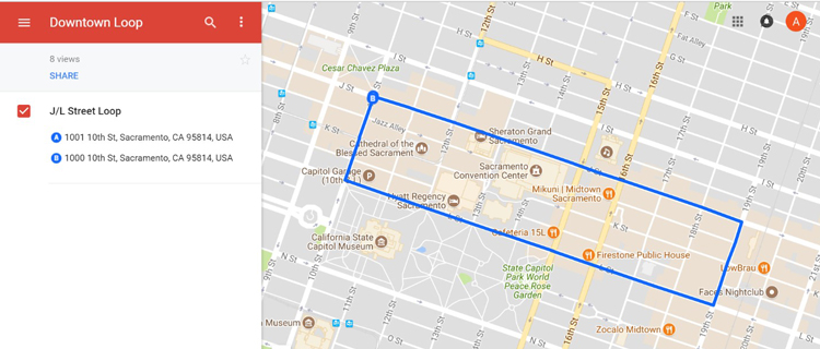
The Downtown Loop
“Sacramento is committed to bringing our residents more shared, cleaner ways to travel,” said Mayor Darrell Steinberg. “This partnership builds on our momentum toward becoming a centre of innovation in new transportation technologies.”
Fusing 2D, 3D and HD data together into detailed and accurately annotated maps is a critical step to enabling safe and reliable autonomous vehicle systems, and so the partnership will create seed maps that the city can share with AV manufacturers. City-created maps of these routes will help advance the local efforts of other individual technology and robotics companies and boost the safe and reliable deployment of AV systems.
“We are attracting the attention of urban technology start-ups because of our willingness to develop alongside them,” said Sacramento Chief Innovation Officer, Louis Stewart. “This partnership allows us to continue shaping Sacramento into an autonomous-ready city.”
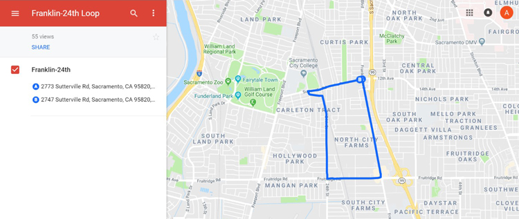
The Franklin-24th route
Such detailed reference maps provide the crucial foundation upon which additional real-time live elements (e.g., pedestrians, other vehicles, weather conditions, etc.) are perceived and safely navigated. Advanced artificial intelligence algorithms, combined with human intelligence, will be used to ensure that every physical element on or around the route is identified and accurately labelled for the AV’s software.
Drones – deployed with advanced sensing technologies, such as lidar, cameras, survey-grade GPS, and inertial measurement units – will be used to capture ground data which will then be further annotated. The multi-sensor data collected will generate high-definition, highly-accurate, colourised, 3D maps.
“We are delighted to be working with progressive and visionary governments like the City of Sacramento and innovative partners like Foresight AI to make the autonomous vehicle dream a reality,” said Deepen AI’s Founder and CEO, Mohammad Musa.
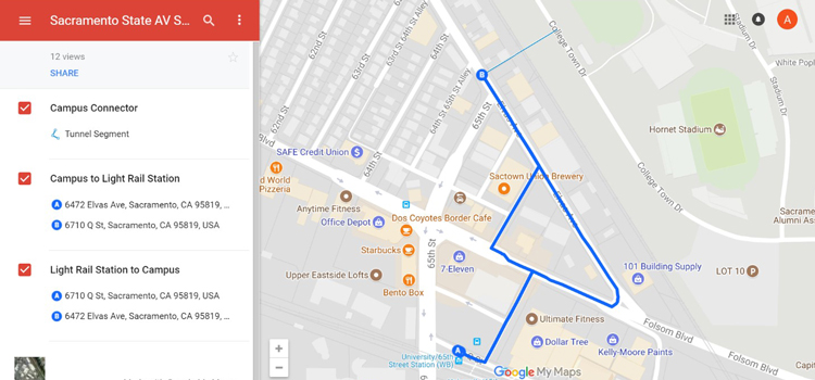
The Sacramento State AV Shuttle route
Related topics
Artificial Intelligence, Connected & Autonomous Vehicles, Infrastructure & Urban Planning
Related cities
Sacramento, United States of America
Related organisations
City of Sacramento, Deepen AI, Foresight AI
Related people
Darrell Steinberg, Louis Stewart, Mohammad Musa