Talking interactive map will improve passengers’ experience of public transport
- Like
- Digg
- Del
- Tumblr
- VKontakte
- Buffer
- Love This
- Odnoklassniki
- Meneame
- Blogger
- Amazon
- Yahoo Mail
- Gmail
- AOL
- Newsvine
- HackerNews
- Evernote
- MySpace
- Mail.ru
- Viadeo
- Line
- Comments
- Yummly
- SMS
- Viber
- Telegram
- Subscribe
- Skype
- Facebook Messenger
- Kakao
- LiveJournal
- Yammer
- Edgar
- Fintel
- Mix
- Instapaper
- Copy Link
Posted: 9 November 2018 | Intelligent Transport | No comments yet
The new ARIADNE Interactive Tactile Map in Norwich has been designed to be easy to use and maintain, with low update costs.
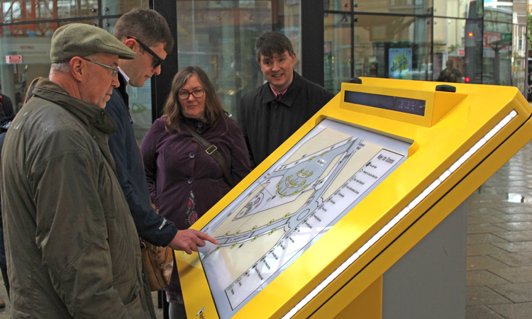
Norfolk County Council (NCC) and Nexus Alpha have announced the deployment of a unique interactive tactile map at Norwich bus station.
This will help all users of the bus station, including those who are visually impaired, to find up-to-date information about bus services and local facilities. Configured specifically to NCC requirements, the map is primarily intended to help users find the right bus stop and local transport facilities.
It incorporates a clear, 3D, tactile image which can be read by touch and respond to the user with audio responses. The map will be continually updated with latest bus information and messages sent by the transport team at NCC.
The area on the map includes the bus station along with stops on the main shopping road, St Stephen’s Street – covering all key local bus routes. When a user touches any icon on the map, it triggers brief audio summaries about what the icon represents. A further tap will provide a second layer of more detailed audio information when available.
Councillor Martin Wilby, Chairman of Norfolk County Council’s Environment, Development and Transport Committee, said: “Around 10 million people use Norwich bus station every year so we want to make sure the site moves with the times and harnesses the best technology to help all the shoppers, workers and tourists that visit our fine city. We’ve worked closely with the Norfolk and Norwich Association for the Blind to make sure this map does a good job and will be a welcome new addition for the future.”
Designed to be fully inclusive, the map is fitted with an RNIB React module, enabling it to respond with a location message and sound as a user with a React key fob approaches. If the user presses a button on the fob, the map will announce any message that is being displayed.
Audio information is straightforward to update, making ongoing cost of ownership very low. The printed map surface can also be easily replaced if physical details of the area change in the future, ensuring longevity of the system.
Julian Coleman, COO Nexus Alpha LPS, said: “We are proud of the ARIADNE map. It is part of our suite of products designed to save cost and improve the use of public transport. The flexibility of the technology is an inherent part of the system, with each installation configured to the requirements of the customer. The NCC transport team has the clearest understanding of what passengers need, and we worked with them to deliver this.”
Related topics
Infrastructure & Urban Planning, Passenger Accessibility, Passenger Experience, Travel & Passenger Information
Related cities
Norfolk, United Kingdom
Related organisations
Nexus Alpha, Norfolk County Council
Related people
Julian Coleman, Martin Wilby