New research shows how to reduce navigational errors in metro systems
- Like
- Digg
- Del
- Tumblr
- VKontakte
- Buffer
- Love This
- Odnoklassniki
- Meneame
- Blogger
- Amazon
- Yahoo Mail
- Gmail
- AOL
- Newsvine
- HackerNews
- Evernote
- MySpace
- Mail.ru
- Viadeo
- Line
- Comments
- Yummly
- SMS
- Viber
- Telegram
- Subscribe
- Skype
- Facebook Messenger
- Kakao
- LiveJournal
- Yammer
- Edgar
- Fintel
- Mix
- Instapaper
- Copy Link
Posted: 16 May 2018 | Intelligent Transport | No comments yet
Researchers are looking into different methods of displaying metro maps and how they can affect the journey planning procedures and consequent mistakes made by users…

Some features in metro maps cause passengers to make substantial mistakes in journey planning however, it may now be possible to detect and fix the mistakes with automated software, research has indicated.
Researchers at the University of Kent recruited 300 participants online to use an on-screen map to plan a number of journeys. Each journey contained one or more ‘navigational hazard’. These could include scenarios where one route switches place with another, merges with another route or passes under another trunk.
Peter B. Lloyd, a PhD student in the School of Computing, is carrying out a series of studies on the New York City subway map. This is sometimes ranked as the most complex metro map in the world, but the results are expected to be applicable to other cities.
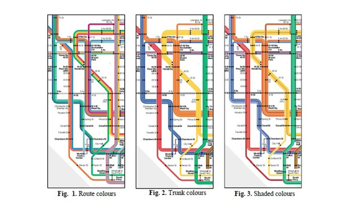
The initial aim of the study was to determine the effect of commonly used colour-coding schemes on the usability of the map, measured by accuracy and navigation speed. The three colour-coding schemes studied, as shown below, were ‘route colouring’ (where each end-to-end route is coloured distinctly), ‘trunk colouring’ (where routes are coloured according to the trunks they run along) and the intermediate ‘shade colouring’.
Participants’ performance when navigating from one station to another was determined by recording how many mistakes they made and how long they took to complete each task.
Their results are consistent with what the researchers predicted. When planning simple journeys with at most one change, the route-coloured map scored the highest usability, but when planning complex journeys with multiple changes, the trunk-coloured map scored the highest usability.
Surprising is the navigational hazards’ large effect on usability. The researchers found that some navigational hazards affect the usability score more than the choice of colour-coding scheme. Furthermore, a few specific navigational hazards reverse the general trend of the effect of colour coding.
The researchers are now carrying out further analyses of the dataset to characterise navigational hazards with a view to developing software for automated detection and correction of those hazards.
Related topics
Passenger Accessibility, Passenger Experience, Public Transport
Related modes
Light Rail
Related organisations
University of Kent
Related people
Peter B. Lloyd