How Malaysian cities can build back better after COVID-19
- Like
- Digg
- Del
- Tumblr
- VKontakte
- Buffer
- Love This
- Odnoklassniki
- Meneame
- Blogger
- Amazon
- Yahoo Mail
- Gmail
- AOL
- Newsvine
- HackerNews
- Evernote
- MySpace
- Mail.ru
- Viadeo
- Line
- Comments
- Yummly
- SMS
- Viber
- Telegram
- Subscribe
- Skype
- Facebook Messenger
- Kakao
- LiveJournal
- Yammer
- Edgar
- Fintel
- Mix
- Instapaper
- Copy Link
Posted: 5 November 2020 | Carol Koh - UK Foreign Commonwealth & Development Office | No comments yet
Carol Koh, Programme Adviser for the Prosperity Fund Future Cities Programme in Malaysia, explains how a Smart Integrated Mobility Management System (SIMMS) in Iskandar and sustainable, integrated mobility planning for UNESCO Heritage City Melaka can change the fortunes of these two Malaysian cities following the COVID-19 pandemic.
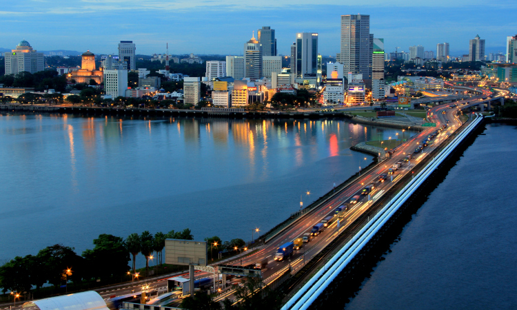
The border crossing between Iskandar Malaysia and Singapore - one of the busiest crossings in the world with an average 350,000 travellers daily
The Global Future Cities Programme as part of the UK cross-government Prosperity Fund is aimed at promoting sustainable and inclusive urbanisation to drive economic growth and achievement of the United Nation’s Sustainable Development Goals (SDGs), working with 19 cities across 10 countries. The two year programme successfully launched in Southeast Asia earlier in 2020 with Mott MacDonald appointed as the delivery partner and UN-Habitat as the global strategic partner.
In Malaysia, the programme is delivering innovative smart mobility projects in two cities, Iskandar Malaysia and Melaka, to help tackle transport challenges and support cities in building back better following the COVID-19 pandemic.
Enabling evidence-based transport and urban planning in Iskandar Malaysia
The Iskandar Malaysia region in Johor, strategically located across the causeway from Singapore, is experiencing rapid population growth which is expected to reach approximately 3 million by 2025. This increase is expected to give rise to many transportation challenges which may impact the socio-economic and environmental well-being of the Iskandar community. Iskandar Regional Development Authority (IRDA) – the authority in charge of planning, facilitating and promoting Iskandar Malaysia – is addressing this issue through the Smart Integrated Mobility Management System (SIMMS), which is being developed with support from the UK Prosperity Fund Future Cities Programme.
Developing a Smart Integrated Mobility Management System (SIMMS) for Iskandar Malaysia
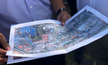
SIMMS (as illustrated in Figure 1) is envisioned as a smart technology-based system that will integrate static and real-time data gathered from a multitude of sources. Geographic Information System (GIS) data on land use, building locations and demographic census data, for example, will be overlaid with transportation data such as road networks, bus routes and timetables as well as traffic flow data to create a visual representation of mobility conditions at any one time. The functionality of SIMMS will be tailor made to the requirements of federal and state administrations but also in consultation with citizen stakeholder groups who can ensure gender, equality and social inclusion is built in so that it meets their needs and aligns to the SDGs.
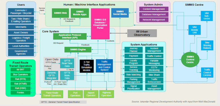
Figure 1: Conceptual framework of the Iskandar Malaysia’s Smart Integrated Mobility Management System (SIMMS)
Having an integrated system such as SIMMS will allow the capacity and efficiency of road networks to be improved as traffic in congested areas can be diverted to other less-utilised roads. Ridership information will also be gathered as part of SIMMS, providing insight into peak usage periods, route popularity as well as journey durations. This will allow for better data-driven decision making for transportation or mobility management planning and fare policies. Efficiency gains from reduced travel times and costs can translate into better economic prospects for a wider population. Optimisation of public transport networks based on population information could provide more access to better healthcare as well as wider employment opportunities. SIMMS will link into journey planner applications to enable better decision making by travellers, providing them with multiple real-time travel options based on cost and journey times. Alleviating road congestion will simultaneously improve environmental conditions by reducing greenhouse gas (GHG) emissions as well as air and noise pollution levels.
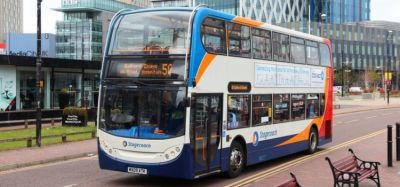
Bus movements at the Kompleks Sultan Abu Bakar border crossing between Iskandar Malaysia and Singapore
Explaining the usefulness of data and SIMMS to the region, YBhg. Datuk Ismail Ibrahim, Chief Executive of the Iskandar Regional Development Authority, say:s “The multitude of data that is gathered via SIMMS will be linked with the Iskandar Malaysia Urban Observatory (IMUO) which aims to use data and analytics to help government, businesses and people to make informed decisions that will evolve Iskandar Malaysia into a more inclusive and sustainable region, embodying our economic, social and environment aspirations. The integration and utilisation of data collected via SIMMS will contribute to evidence-based urban and transport planning in line with the Global Future Cities programme objectives.”
In light of the COVID-19 pandemic, strict government standard operating procedures (SOPs) have been implemented to curb the spread of the virus, with physical distancing requirements and limitations to operation hours adding to the mobility challenges that are faced by populations globally. Information on employment levels, journey maps as well as public transport ridership could be used as basis to adjust public transport routes and increase bus or train frequencies, such that communities are still able to get to their place of employment or access education facilities whilst keeping in line with COVID-19 limitations.
The increase in mobility efficiency and access based on the implementation of SIMMS could serve as the impetus needed for a step change from dependence on private vehicles as a mode of transportation, to wider adoption of public transportation as a primary form of travel. As has been widely documented during the pandemic lockdown period, the reduction in vehicles both on land and on water has led to significant improvements to the environment. The mobility improvements that can be gained through wider adoption of SIMMS in cities globally will have the potential to increase their pandemic and environmental resilience, especially in the ‘new normal’ that we are faced with today.
Smart, sustainable and integrated mobility planning for a UNESCO Heritage City
Historical buildings are preserved in the Melaka UNESCO Heritage Area while modern developments emerge in other areas of the city
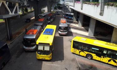
The Global Future Cities programme is also supporting Melaka – a historic city in Malaysia with a population of nearly a million people. In 2008, the city centre was inscribed on the list of UNESCO World Heritage Sites. Due to its attractiveness to domestic and international tourists, the city is experiencing rapid growth as well as traffic congestion challenges with low public transport ridership and high usage of private vehicles. Active modes of travel such as walking and cycling are difficult to promote due to Melaka’s equatorial climate, with temperatures rising to up to 36˚C during the day. To tackle the challenges, the programme will be delivering two interventions to improve connectivity to and from the city’s Heritage Area, and the mobility network within the Heritage Area.
Intervention 1 is to develop a Green Bus Network Implementation Plan which will enable Melaka to implement the right infrastructure and mobility system to promote sustainable travel along Melaka’s key access routes. The intervention aims to transform the existing bus service into a sustainable and efficient network, providing reliable access to facilities such as hospital and schools as well as employment opportunities to increase social inclusion. This network will be served by a renewable energy-fuelled bus fleet and enable the roll out of innovative public transport technologies, such as smart traffic management and smart ticketing. The wider network management will be to plan and promote park and ride facilities to reduce vehicles entering the Heritage Area and ease congestion within the city centre. A traffic model will be developed to help identify the most effective locations for park and ride sites in order to encourage modal transfer. Other measures such as fare incentives and infrastructure improvements to improve journey time reliability will also be considered to provide a further boost to bus patronage.
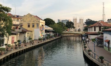
The Melaka River and pedestrian walkways have undergone developments to promote active travel in the Heritage Area
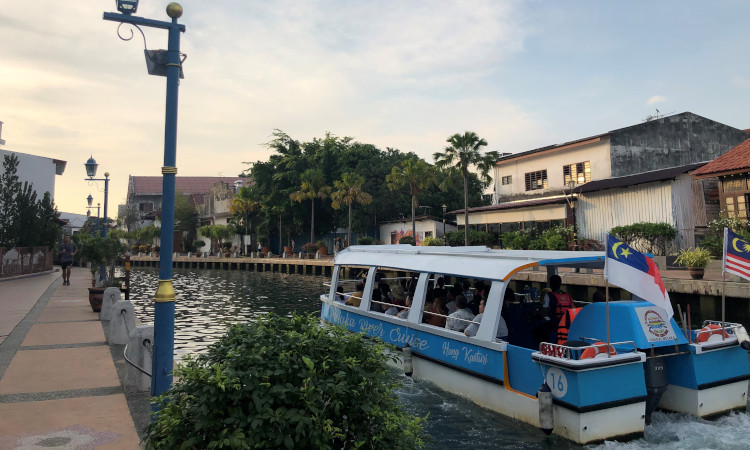
Intervention 2 is to develop an integrated mobility plan for the Heritage Area, which will link directly to Intervention 1 to ensure sustainable travel in the city’s central area. The aims of this intervention are to alleviate the Heritage Area from the stresses caused by traffic congestion and promote urban improvements in a post-COVID-19 economy. This will consider and propose alternative modes of transport to the private and motorised vehicle with a focus on walking and cycling, intelligent transport systems (ITS), public, water and non-motorised forms of transport. Strategies for an integrated mobility system within the Heritage Area will be outlined as well as its connection with the wider transport network at a regional level.
The Melaka interventions align well with the ‘Build Back Better’ initiative as they both aim to provide more inclusive, safe and accessible public transport for all including vulnerable groups such as mobility-impaired users, women, children and the elderly. The sustainable transport modes that are promoted will contribute to reduced carbon dependence and help alleviate the impacts of climate change. These will support improvements in the environmental and socio-economic health of the city in the form of reduced GHG emissions, air and noise pollution, a safer and calmer urban environment, heritage protection, and a more resilient local economy.
“A digital model of Melaka will be developed in collaboration with the Melaka Government using existing information and information. This ‘digital twin’ will enable the local authorities to adopt a data-driven approach to plan, manage and operate the city’s infrastructure, also supporting the planning of urban spaces to accommodate a post Covid-19 society by creating more unrestricted space in the Heritage Area for effective social distancing and improve infrastructure planning to accommodate active travel modes,” says Michael Curthoys, Country Lead, Mott MacDonald Malaysia – a Prosperity Fund Future Cities Programme Delivery Partner.
Driving impact through cross-border collaborations
A core part of the programme will be to provide technical assistance and capacity building to equip local institutions with the skillsets required to ensure a lasting impact of the projects. There will also be opportunities for cities to share learnings and collaborate with each other via the programme’s global network.
“The UK is a world leader in many elements of the future cities concept. We take a holistic approach to future cities development, taking into account social, environmental, economic and political considerations. Through the UK Prosperity Fund Global Future Cities Programme, we are supporting Malaysia in its future cities ambitions, encouraging the sharing of learning as well as technology and knowledge transfer through international collaborations and partnerships.”
– His Excellency Charles Hay, British High Commissioner to Malaysia
Biography
Carol Koh is the Programme Adviser for the Prosperity Fund Future Cities Programme in Malaysia under the UK Foreign, Commonwealth & Development Office. She is an advocate of sustainable cities development and the founder of Books on the Move, a non-profit movement in Malaysia making books more accessible via community placemaking.
Related topics
Infrastructure & Urban Planning, Mobility Services, Public Transport, Traffic Management, Transport Governance & Policy
Related organisations
UK Foreign Commonwealth & Development Office
Related people
Charles Hay, Datuk Ismail Ibrahim, Michael Curthoys